PROJECT DESCRIPTION
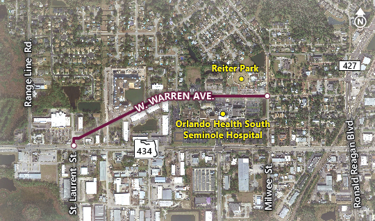
The City of Longwood is conducting a complete streets study on West Warren Avenue between State Road 434 and Milwee Street. This project was approved by the City of Longwood as a part of their Complete Streets Policy Opens new window ; a commitment to provide safe transportation options for all users.
The purpose of this complete streets project is to:
- Enhance connectivity and accessibility between all modes of transportation, activity centers, and neighborhoods surrounding West Warren Avenue
- Create a safe and supportive environment for walking and biking
- Create a Multi-modal Vision and Plan that supports the City’s Economic Development initiatives
- Develop a set of implementable improvements (alternatives) in the study area that can be designed and constructed
ANNOUNCEMENTS
The study team presented the final study recommendations for input and approval from the City Commission on April 4, 2022. For additional details (location, time, etc.) please visit the Public Meetings page or view the recording on the City's Facebook page.
STUDY AREA
West Warren Avenue in the study area is a critical connection in the City of Longwood. It provides an entrance to the City’s Historic District, and is located in Longwood’s Heritage Village, which is anchored by the City’s SunRail station, located approximately one quarter mile from the eastern boundary of the project. West Warren Avenue is also surrounded by residential, commercial, and recreational land uses which have been growing in the past years and are projected to continue to grow. As such, the provision of multi-modal access for residents, visitors, and workers along the West Warren Avenue is key to the continued healthy growth of this corridor.
THE GUIDING PRINCIPLES FOR WEST WARREN AVENUE
- Improve Access and Connectivity Along the corridor
- Improve access to residences, jobs, medical facilities, and parks by:
- Improve bicycle and pedestrian connections to recreational, educational, and community destinations, including Reiter Park, South Seminole Hospital, and Longwood’s Historic District through addition of sidewalks or paths and enhanced crossings
- Enhance the connections to existing and future transit services
- Provide for additional event parking and traffic management through dynamic messaging signs
- Invest in Aesthetic and Functional Transportation Improvements
- Improve the safety and experience of all roadway users by:
- Improve drainage facilities along the corridor
- Add street lighting where appropriate
- Improve landscaping along the corridor, including accommodating existing trees and planting shade trees along the corridor where possible
- Relocate and bury utilities along the corridor
- Relocate dumpsters currently located behind 745 SR 434
- Incorporate murals / public art on back of commercial buildings
- Incorporate brick paver crosswalks
- Provide intersection improvements to reduce the crash rate and improve bicycle and pedestrian connections at St. Laurent Street and West Warren Avenue
- Support the City of Longwood’s Other Livability Goals
- Create flexibility in infrastructure to accommodate community-building events, and enhance the balance of land uses:
- Facilitate community events when desirable, creating synergy with local public places
- Encourage community-building with the Historic District to enhance economic development
- Facilitate cafes, breweries, and other community-oriented businesses with options for sidewalk seating
- Review allocation of land uses to determine viability of bicycle or pedestrian trips
- Improve connectivity between uses, including employment centers and residential buildings
- Increase connectivity to existing mixed use zones, including Longwood’s Historic District
PROJECT SCHEDULE

Assess Existing Conditions and Define Guiding Principles (November 2020 - May 2021) COMPLETED
During this phase the project team will collect information and data related to the existing conditions of the study area related to engineering, environmental, land use, traffic, crashes, transit, drainage, hydraulic, data and complete streets elements necessary to develop and evaluate a reasonable range of alternative improvement concepts. Guiding Principles will be developed to provide the structure for the examination of multimodal treatment options and the framework to evaluate various alternatives. The results of the existing conditions assessment and draft Guiding Principles will be presented at a Public Workshop to gain input from project stakeholders.

Define and Analyze Alternatives (May 2021 – December 2021) COMPLETED
The project team will develop alternative improvement concepts and analyze the benefits and impacts associated with each improvement concept. Alternative improvement concepts will be presented at a 2nd Public Workshop to share the results of the alternatives development and assessment and to solicit feedback from the community. Results of the analysis will be documented in the study reports. The selection of recommended improvements will be made at the end of this phase.

Refine Recommended Improvements (December 2021 – April 2022)
COMPLETEDFollowing completion of the alternative analysis, the project team will refine the recommended improvement concepts to finalize the major elements of the project. These refinements will include estimating the final recommended right-of-way limits, pond locations, cost and other major features needed to advance the project to the subsequent design phase. The draft refined recommended improvement concepts will be presented during a regularly scheduled City Commission meeting.
Contact Us
Shad M. Smith, PE
City of Longwood
Director of Public Works/City Engineer
(407) 260-3447
ssmith@longwoodfl.org
Opens a new window in your email
Amy Sirmans, PE
VHB
Consultant Project Manager
(407) 641-0688
asirmans@vhb.com
Opens a new window in your email